Mapping Terms and Definitions
Georeferencing:
The process of adding geographic information to a dataset (imagery, lidar, etc) so that the internal coordinate system of a digital map or aerial photo can be related to a ground system of geographic coordinates. A georeferenced digital map or image has been tied to a known Earth coordinate system, so users can determine where every point on the map or aerial photo is located on the Earth's surface.
Geospatial Data:
Time-based data that is related to a specific location on the Earth's surface. It can provide insights into relationships between variables and reveal patterns and trends.
Map Projections:
Portrays the surface of the earth, or a portion of the earth, on a flat piece of paper or computer screen. In layman’s term, map projections try to transform the earth from its spherical shape (3D) to a planar shape (2D).
Coordinate Reference System (CRS):
A CRS is a coordinate-based local, regional or global system used to locate geographical entities. A CRS commonly defines a specific map projection used to represent the 3-dimensional surface of the earth on a 2-dimensional plane.
In other words, a CRS defines how a digital map or geospatial data relates to real places on the earth. The decision of which map projection and CRS to use depends on the regional extent of the area you want to work in. For 3D geospatial datasets, the CRS includes a horizontal datum and a vertical datum.
Datum:
A parameter or set of parameters that define the position of the origin, the scale, and the orientation of a coordinate system
Vertical Datum:
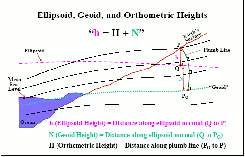
A set of fundamental elevations to which other elevations are referred. There are 3 types of vertical datums: geodetic (Ellipsoid heights), orthometric (Orthometric heights derived from Geoid model) and tidal vertical datums. These datums can be in geographic, geocentric, or projected coordinates.

Ellipsoid:
A mathematical idealized representation of the physical Earth. An ellipsoid is modeled as an oblate spheroid which resembles a ball being sat on. Geodetic vertical datums reference an ellipsoid model and elevations are in “Ellipsoid Heights”
Geoid:
A geoid is a model of global mean sea level that is used to measure precise surface elevations in “Orthometric Heights”. The geoid surface is irregular, unlike the reference ellipsoid, but is considerably smoother than Earth's physical surface. Orthometric vertical datums reference a geoid model. Geoid Models include undulating offsets known as “Geoid Heights” (represented as “N” in the above image under Vertical Datum) or the difference between an Ellipsoid Height and an Orthometric Height.
Horizontal Datum:
A specified coordinate system for a collection of positions on the surface of the earth. The horizontal datum generally includes a map projection.
Static Datum:
A static datum is “fixed” to a tectonic plate. The reference points move along with the tectonic plate and the coordinates appear to be unchanging, or static, over time. These datums have a fixed Epoch (For example NAD83 (2011) has a fixed Epoch of 2010.000)
Dynamic Datum:
A Dynamic datum is “fixed” to the Earth as a whole, and aligned to the center of the Earth’s mass. The reference framework moves with the Earth, so the coordinates of reference points on a tectonic plate appear to be dynamic, or changing over time. These datums have a dynamic Epoch (For example, if you collect data in the dynamic WGS84 datum, the epoch would be 2021.35 on May 5, 2021). Also see definition for Epoch below.
Realization:
A datum tag which indicates the tectonic plate to which the coordinates are referenced and the year in which the realization was completed with the epoch date in decimal years. The Realization is generally expressed as a realization year in parenthesis followed by an epoch date, or expressed by a series of letters/numbers in parenthesis.
Note: One thing to keep in mind is that the definition of the coordinate system does not change. For example, the ellipsoid used to define geodetic datum NAD83 does not change as the surface (tectonic plates) moves. The points on the surface of the earth just get new coordinates or “realizations”.
For example, previous to 2012, there were other “realizations,” of NAD 83, each driven by improvements in GNSS observations. The realization name has two parts: the datum tag in parentheses after NAD 83, and the epoch date in decimal years.
Epoch:
A scientific term used to denote a specific moment or period in time. Land surveying and geodesy use a numerical “epoch” in decimal years to state the moment at which a given position—in geodetic latitude and longitude or plane coordinates (e.g. northing and easting) and ellipsoid heights—is valid with respect to the geodetic datum.
The decimal year is equal to: year + day-in-year/365 (366 for leap years). For example, January 1, 2010 is written as 2010.00; May 5, 2021 is the 128th day and written as 2021.35.
Last updated